laura paddles delmarva

Circumnavigating 600 miles of Delmarva's shorelines


Leave a comment

Kingston Marsh

On August 28, the Y members and I headed out of Kingston Landing.  The landing is directly on the Choptank, but after a few hundred yards we turned off into a small creek to the right.  Check it out:

Calm waters provided great photo-ops!

The weather was perfect and the water was extremely still.  I love paddling this creek because you do not pass any developed shorelines.  We even paddled passed a piece of land that is owned and/or managed by the Nature Conservancy.  What makes the property unique is that there is only water access to it, a small dock, so you can only reach it by small boat.  The only drawback is that there are private residences that border it and I’ve seen them drive around the property in golf carts and minivans.  Rude if you ask me!

The creek winds back and forth a bunch of times so if you like exploring and wondering what’s around the next bend, this trail keeps you on your toes.

After we turned around and started heading back, the sky became filled with migrating birds.  Some of them swallows and some of them red-winged blackbirds.  There may have been some starlings too.  What amazed me was just the sheer number of them – thousands and thousands!  As we paddled along, huge clouds of birds started bursting out of the marsh grasses.  What fascinated me the most was the sound of all their wings beating at once – surprisingly loud and surprisingly peaceful at the same time.

Gorgeous evening. Notice the birds in the sky.


Leave a comment

Skipton Creek

Bald eagles galore!  On August 21, I took the Y to Skipton Landing.  I’ve been to this landing many times and we typically head down the main creek towards Wye Island.  This time however, the tide was up high enough that we could make it up a smaller creek that heads off to the north.  Check out our path:


Now, I’ve seen enough bald eagles in my life that seeing them now isn’t quite as exciting as it used to be.  However, this creek was filled with them!  I’ve never seen so many in such a short distance!  At times there were 4 or 5 sitting in one tree and one would fly over the creek every 10 or 15 minutes.  I do realize that we were probably seeing some of the same birds multiple times, but it was still pretty exciting.  And if it wasn’t a bald eagle, it was an extremely chatty great blue heron.  The herons in this creek were noticeably louder and squawked more frequently than normal.


1 Comment

Hillsboro Landing on the Tuckahoe River

I brought the YMCA’s kayak club to Hillsboro Landing on August 14.  We launched in the town of Hillsboro and paddled upstream into Tuckahoe State Park.  I’ve paddled this stretch of the river several times, but it is still one of my favorite spots in the area because the scenery is drastically different from most of the other landings in the county.  As you head upstream, the river gets more and more narrow, with more and more fallen trees to maneuver around.  I believe the park system maintains the water trail because there are various trees that have been cut through and spray painted bright orange to help you navigate and stay on course.

Here’s the path we took:


I wonder if she said yes…

Navigating tight spots around downed trees


No one was brave enough to play on this old rope swing


Leave a comment

Taylor’s Island to Hooper’s Island

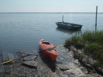
The weather was perfect for kayaking on Sunday, August 12 for a long paddle so I decided it was time to cover some serious mileage. Brian dropped me off at the public boat ramp in Taylor’s Island around 11:30 and he planned to meet me at the Smithville landing a few miles away.

Since my last solo trip I decided I needed more safety equipment so I purchased a paddle float, bilge pump, and a whistle. Brian bought me a marine VHF radio too.  Now that we both have radios, we can keep in contact, even when there’s no cell service. I felt like a pretty hard core paddler with all that stuff strapped to my kayak!

I started out by heading south. The wind and the tide were with me so I was able to paddle at a leisurely pace.  The first and only person I encountered on this whole trip was right after I went underneath the Taylor’s Island bridge.  This guy was spending his day trot-lining – looked like he had almost a bushel of crabs.  I think I creeped him out when I took this photo, probably thinking I was some stupid tourist, but I wasn’t quite in earshot to say hello.

For about 90% of this trip, I was surrounded by nothing but marsh and trees.  Not a person, boat, house, not even a power line in sight.  However, when I say nothing was in sight but marsh and trees, I mean it.  The wildlife sightings were at a minimum.  I saw a few terrapin heads pop up, 3 bald eagles, and the occasional great blue heron scaring the crap out of me with their obnoxious squawking.  The absence of wildlife was not what I expected, paddling in such remote habitat, and being in close proximity to the Taylor’s Island Wildlife Management Area and Blackwater National Wildlife Refuge.

I did see this bald eagle nest though – kinda cool.

About a half hour into my journey, my radio pipes up saying “Euryhaline, this is Banana Hammock, do you read me?”   Yes, Brian named his kayak the banana hammock.  So if you’re ever cruising around Delmarva, turn to channel 9, you might catch our stupid conversations.

Here is one of the sightings that I got most excited about – sea lavender.  This native plant commonly grows in marshes, but I think it is more commonly seen closer to the coast.  I hadn’t seen sea lavender since I worked at Delaware Seashore State Park back in 2009.

As I rounded one of the last bends before reaching the Smithville landing, and just over an hour of paddling alone, I spotted this guy!  No luck with the fishing yet so he paddled to the landing with me.  After eating a quick lunch I decided I was up for more so I took off again, still heading south.  Brian said he would meet me at the next bridge (MD-335).  It’s a damn good thing I have Google Earth on my phone or I would have never found that bridge.  The water trails through the marsh islands basically make up a giant maze and when you’re sitting low in a kayak, it is almost impossible to navigate unfamiliar territory.

Maybe 45 minutes later I spotted Brian standing next to the bridge, ready to pull me out.  Well, I wasn’t ready.  The tide and the wind were still perfect so he agreed to meet me at the first bridge going to Hooper’s Island.

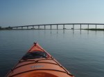
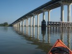
Oh em gee.  I hate open water.  Seriously.  Even though the tide and the wind were all in my favor, I felt like I was going nowhere!  Not being close to the shoreline and easily seeing your progress, it can be mentally exhausting, leading to physically exhausting.  I had to count my strokes and force myself to do 24 strokes before I rested again.  This last 2 mile stretch (or thereabouts) was by far the worst part of today’s trip.  When I reached the bridge by Tyler’s Cover boat ramp, I felt like my arms were going to fall off.

Brian spent another half hour or so catching spot (to use at bait later) while I relaxed and admired the distance I covered – 13.42 miles in 3 hours and 51 minutes.  Check out my path:

And I finished the day with a well deserved strawberry shortcake ice cream bar!


Leave a comment

Trappe Landing

On Saturday, August 11, Brian and I went kayaking out of Trappe Landing.  On the way to the landing we drove through “downtown” Trappe which I had never seen before.  Cute little town, might be worth coming back to eat at one of the restaurants, but if you blink, you miss the entire town.

We spent almost 3 hours paddling aimlessly, Brian fishing most of the time, me bobbing around and relaxing.  We covered a total of 5.35 miles so in 3 hours, you can do the math and figure out how SLOW we were going.  As “La Trappe Creek” (all the docked boats had the “la”) started to open up to the Choptank, a strong wind began to push against us so we decided to turn around and slowly head back to the landing.  Unfortunately, a storm started to roll in from the south (thank goodness for smart phones) so we picked up the pace and made it to back to the landing just in time before the rain hit.  Not much thunder, just a downpour while we were loading the kayaks back on the car.

Here is the path we took…

And here is some of Brian’s catch…


Leave a comment

Secret Launch on the Choptank

On Tuesday, July 3, the YMCA’s paddle club was invited to launch from a member’s private property.  I probably shouldn’t disclose the exact location of this launch, but it was on the Choptank, not too far south of the Dover bridge near Easton.  We started out by paddling directly across the river into some hidden marsh creeks.  I was amazed at how easy it was to get disoriented and lost amongst the Phragmites and Spartina grasses.  We didn’t want to get totally lost so every time we had a choice of direction we took a left, and once we turned around, we knew only to make right turns.

Once we had our fill of exploring the marsh creeks we headed up the Choptank about a 1/2 mile and explored the exposed cliffs of an eroded riverbank.  We were able to see distinct layers of soil and various shells – mostly scallop shells!  Apparently at low tide this place is a hot spot for finding arrowheads – too bad we were pretty close to high tide.

We paddled at a pretty leisurely pace, covering just over 3.5 miles in about an hour and a half.  It was crazy hot and humid and there was no sense in overdoing it.  Take a look at our path:


Leave a comment

Pierce Taylor Road – Wisharts Point

To sum this paddle up – hot and boring, until the last few minutes.  I set out on the water early on June 30 because the high temperature for the day was somewhere around 103 degrees!  I was in the water at 7:45 and expected to be finished by 9:15 so I would miss the heat of the day.  There wasn’t much to see on this trip for whatever reason.  A few gulls, a few willets, and one cormorant – certainly nothing to write home about.  I did however hear a Bobwhite at the landing before I hit the water!

I paddled a total of 6 miles in an hour and a half – exactly what I expected.  It was pretty cool to paddle underneath the Wallops Island access bridge.  I had been across it numerous times by car and I never realized how tall it was!

I’ve been kayaking for 6 years now, however, this was the first paddle where I encountered cows!  As I was nearing Wisharts Point I passed a small waterfront farm.  From a distance I thought there was some kind of debris along the shoreline.  As I approached closer, it was a herd of cows!  Clearly the day was heating up as the cows were probably in the water well before 9 a.m. and I was drenched with sweat.  Shortly after pulling my kayak out of the water I headed straight to the beach to cool off and go swimming.


Leave a comment

Goldsborough Creek

I took the YMCA’s Tuesday Night Kayak Club to Goldsborough Creek on Tuesday, June 26.  The wind was strong enough that there was a small craft advisory so we decided to stick to a creek that was relatively protected from the NW wind.  The 5 of us paddled up a creek until we were hitting bottom.  We spent quite a bit of time marveling at some of the waterfront homes and guessing what the homeowners did for a living – gorgeous houses with beautifully landscaped yards and even a few boathouses.  The creek was also filled with great blue herons, a few osprey, and lots of jumping fish!

We covered 3.74 miles in about and hour a half.  Here is the path we took:


Even though the afternoon was very windy out on the open bay, the evening turned out to be extremely peaceful.  Fun was had by all.


Leave a comment

Wisharts Point to Queen Sound Landing

On Sunday, June 24, I completed the first leg!  I started at Wisharts Point which is in the town of Atlantic, VA.  I paddled 7.93 miles to Queens South Landing which is located just off the Chincoteague causeway.  It took exactly 2 hours.  Take a look:

I was pretty stoked to start this journey.  I hope that smile in the beginning remains throughout the coming years!  And you gotta love Brian’s fabulous photography, with that artsy, tilted horizon.  I also had to crop out his finger.  Good thing I’ll be taking most of the photos for this blog!

The first part of this paddle was a bit boring because it was mostly open water and not much to look at.  However, as I entered the marsh creeks, wildlife was abundant.  Plenty of nesting laughing gulls, terrapin heads popping up every which way, and sting rays!  I saw 3 huge sting rays that were practically swimming on the surface of the water.  All of them were at least 20 feet away as I saw their wing tips breaking the surface.  Although this was a cool sight, I’ll always keep my distance – I was stung in the ankle 3 years ago and am literally scarred for life!

I timed this paddle well because the tide and wind were with me most of the way.  Even though the elements were on my side, I was still exhausted during the last 2 miles.  Every time I stopped to wipe the sweat away I swear the clapper rails were laughing hysterically at me (their call sounds like an evil cackle, always hidden in the marsh grasses).

I felt pretty accomplished as I pulled up onto Queen Sound Landing.  8 miles in 2 hours isn’t bad!  This made me optimistic for some of the longer legs I have planned in the future.  Next up, a leisurely paddle in Goldsborough Creek in Easton, MD.

Wish me luck and enjoy this blog!  I’d love to hear your feedback.  If you ever want to join me for a paddle, please let me know – it could get lonely out there!


Leave a comment

A Few Basics and Logistics

I put some thought into the “About” section of this blog to explain the purpose of this adventure.  The “About” section is a little sappy so I’m going to start my first blog post explaining the logistics of this endeavor.

My name is Laura and I plan on paddling around the entire Delmarva peninsula before I die.  It sounds daunting but I figure I’ve still got at least 40 good years of paddling in me.  I spent a few days on Google Earth plotting my intended course.  This was much more difficult than I expected.  There are many public landings, boat ramps, and water access points, but sometimes the geographic locations make it difficult to plan the journey.  I was able to break it down to about 95 legs, covering 695 miles.  I’m sure I won’t stick to it exactly, but it at least gives me a rough plan.

Another decision that was difficult to make was to decide how far inland I would paddle.  Should I paddle straight across the the mouth of the Chester River, or should I paddle several miles upstream and and several miles back?  My rule of thumb is to never be more than 2 miles from shore, and in most cases, less than 1 mile.  If I paddle straight across the mouths of all the tributaries, I’ll be missing some of the best opportunities for new scenery and new wildlife sightings.

Most of the legs will have to be one-way.  I don’t want to paddle out 10 miles, and then have to paddle back – seems like a waste.  Brian (boyfriend) has agreed to help with this dilemma when he can; he will drop me off at the start, paddle with me for a little while, fish for a little while, and then drive to pick me up at the finish.  I am also happy to have friends paddle with me, that way we can leave a car at the start and the finish.  If anyone else has some creative ideas for the logistics, let’s hear it!

As a fun part-time job, I lead weekly kayak tours for the local YMCA.  I will be including these paddles in this blog as well.  All of these trips are out-and-back trips that will be covering creeks that are not part of the overall adventure, but should add some diversity of scenery.

I am starting this journey in a 12′ Necky Looksha.  I’m sure I’ll want to upgrade eventually, but for now, it’s still perfect for me.  I’ll be bringing my smart phone which has GPS, marine weather forecasts, tide charts, and other nifty apps.  On longer paddles, I’ll be bringing a marine VHF radio with me for emergencies.  I have an awesome PFD and I’ll be purchasing a paddle float, bilge pump, and other kayak safety equipment.  And of course the standard dry bag with first aid kit, sunblock, bug spray, camera, snacks, etc.  Oh, and a few water bottles would be good too!

I hope to track every leg with the “My Tracks” app.  It’s quite handy and tracks your exact path onto Google Maps.  Then I can display the map on this blog.  It even calculates your average speed, omitting time stopped for breaks.

I think that’s it for logistics.  Stay tuned to hear about the first trip!