It has been 1 YEAR since I got some real mileage in so today I got back in the saddle and logged a few miles. For anyone just joining, or for those of you that don’t remember, my ultimate goal is to paddle around the entire Delmarva peninsula before I die. I started about 6 years ago and so far I’ve paddled 266 miles of 675; 40% complete!
I chose to paddle from Hoopersville to Wingate today because I had a work field trip to the new Harriet Tubman visitor center in Church Creek. I actually got this tired-mom-butt out of bed at 4:30 this morning so I had time to complete the paddle before my 10:00 meeting!
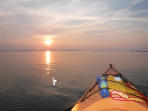
I arrived at the Hoopersville boat ramp a little before 6:30 a.m. (thanks to Brian for dropping off Patrick at daycare!). It’s been a while since I was in a scenic place for sunrise, but the sun peeked above the horizon’s haze right as I was about to launch.
The winds were pretty much calm when I started out which normally makes for very enjoyable paddling, but oh my gosh, the FLIES! If I was within 20 yards of the shoreline, I got SWARMED! I’ve been in some nasty buggy situations in my time but this one takes the cake! At one point I may have had 40 flies on me, being bitten by half of them. Luckily nobody was around because it probably looked like I was having a panic attack or seizure, trying to swat them away. I was literally screaming it was so bad.
I finally got far enough away from the marsh to avoid the flies and was able to enjoy the paddle.
I did get to snap this photo of an old tractor on the edge of the marsh before the flies totally took over. I am really curious about this tractor’s story. There’s no road, no farmland, nothing but marsh grass and water for at least a mile radius from this tractor. Maybe someone just dumped it there a few decades ago? Who knows.
Another interesting thing about this trip is that I had no satellite service to track where I was going. Usually I am referring o my GeoTracker App every so often to make sure I am headed in the right direction. The app typically works in the most remote locations, even when I have no cell signal, so this time I had to just navigate by the map I had in my head from looking at Google Earth the night before. My goal was to paddle across the mouth of the Honga river and then head back to Hooper’s Island which was pretty straightforward. Had I been paddling a section of intricate marsh creeks I would’ve been screwed without a map!
Once I neared the end of Hooper’s Island I turned out to cross the Honga and then reached a point of land near Wingate. The trip so far was 4.78 miles but I still had to turn around and head back to the boat ramp, so even though the total trip was 8.8 miles, only the 4.78 counts towards my overall goal. It kinda sucks to put in “extra miles” that “don’t count” but then again, it’s still great exercise, and peaceful solitude spent outdoors so I shouldn’t complain. It’s just not feasible to always to a one-way trip.

View returning to Hoopersville ramp
The return trip was tiring. It was basically a solid 4 miles of open water against the wind that had picked up. But I got across and back to the boat ramp in about an hour, with plenty of time to drive back up to Church Creek and change out of my stinky clothes for my meeting!
Here’s the path I took for the first 4.78 miles (the miles that COUNT):


