Another Monday off, another 6.7 miles in the books! Today I paddled from Trappe to Cambridge. My sister, Julia, is on the east coast right now, bouncing between Baltimore County and Ocean Pines to visit with family. She was headed back to the western shore this morning after spending the weekend with us in Ocean Pines, so I took advantage of her driving west, to shuttle me across the Choptank River.
I left the house at 5:30, about 20 minutes ahead of her leaving. I drove straight to Trappe Landing, unloaded my kayak and locked it to a lamp post, and then drove to Gerry Boyle Park in Cambridge. I parked my car there and Julia picked me up and drove me back up to my kayak in Trappe – that way I didn’t need to ride my bike across the Route 50 bridge (I don’t think you’re allowed to do that anyway).
As I was getting ready to launch, I realized I left my bilge pump at home somehow. No big deal, unless this was to be the trip where I capsized for the first time. As I was about to launch, an old man (like he was pushing 90) was wandering the landing and struck up a conversation with me. “You don’t have much room in that thing!” LOL! I told him I had enough room for myself and that was all that mattered. Then he asks, “you ever fall out of that thing? I’ve seen on the television people that roll down in the water.” I told him I never have, but there’s a first time for everything! And of course as soon as I said good-bye and paddling out of the landing, I started to wonder if the universe was against me and that I was totally going to capsize on this trip!
Nevertheless, I continued on my journey, knowing that I really had no choice, because I was literally stranded in Trappe and my car was several miles of paddling away.
 The creek out of Trappe was delightful. The sun was just starting to make the water sparkle, and I enjoyed admiring all the fancy homes and docked sailboats along the way. Several small pleasure boats and someone on a SUP passed and waved. Such a friendly little creek!
As I came around the point and entered the Choptank the wind and chop started to hit me. My original plan was to paddle along the northern shoreline of the river, then cut across the river adjacent to the bridge, since I felt safer from boat traffic doing that. But the wind was really sloshing me around on the north side, and the boat traffic in the river was light, so I decided to take a turn to the south and head straight across. You can easily see on the map where I made the decision to cut across:

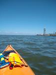
my attempt at a pic of the sailboat in the choppy water
It wasn’t bad. The work boats in the area were nowhere near me, and the sailboats kept their distance. By the way, I think this is the first time in over 300 miles that I’ve really encountered any sailboats – hard to believe!
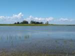
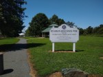
Once I got across the river, I had to take a minor detour due to a long jetty that was in my way. Not as bad as the detour I had to take around the Slaughter Beach jetty a few weeks ago, but it was still mildly annoying. Once I rounded the tip of the jetty, it was a short, straight shot to the boat ramp at Gerry Boyle Park (which by the way, super cute park with a pavilion, boat ramp, playgrounds, walking path, and beautiful views of the Choptank).

Oh hey – and I never capsized 🙂
 I swapped my bike for my kayak and locked my bike to the sign post. I hit the water a little before 10:00. Some much more experienced cyclists were enjoying the view from the landing and wished me a nice paddle, and we both commented on what beautiful weather it was for both kayaking and biking. As I rounded the southern point of Neavitt, I looked across the water at Tilghman Island and thought – yikes, that looks really, REALLY far away! After about a minute of paddling around the corner, more land came into view and I realized what I had been paddling towards was Cambridge! Yikes! Good thing I only paddled a minute in that direction before realizing that was the wrong direction! The actual Tilghman Island looked waaayyyyy closer and much more doable. I’ve said this in many posts before, but DANG do I get disoriented on the water sometimes! Thank goodness for GPS and my awesome GeoTracker app, or I would’ve had to hitchhike from Cambridge to Tilghman. In the middle of a pandemic.